3.8.2 Lineament (Lineament)
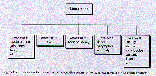
3.8.2.1 A lineament is a linear or curvilinear feature that is directly visible on the Earth's surface, or stands out on either topographical or geophysical maps, or on satellite or aerial photographs. Lineaments are assumed to reflect a geological inhomogeneity in the bedrock, such as a fracture, rock boundary, fold, linear rock body or ore body (Figs. 14, 15). Lines of intersection between the surface and foliations are not looked upon as lineaments.
3.8.2.2 Lineament is the fundamental term for a linear structure of unknown, uncertain, partly known or mixed geological origin.
3.8.2.3 No limitations are placed on the dimensions of a lineament in the field, but on the scale on which it is relevant to show it a lineament is depicted as a line.
3.8.2.4 The structure is mappable at the surface with the help of geomorphological, geological or geophysical methods. A lineament can be defined on the basis of one or more types of remote-sensing data, such as satellite or aerial photographs, gravimetric, magnetic and seismic measurements, etc.
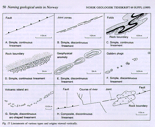
3.8.2.5 A lineament often consists of two or more parallel or subparallel, straight or gently curved linear segments. These segments may have different origins and extents, and may form parts of continuous or discontinuous lineaments (Fig. 15). Discontinuous lineaments consist of separate linear segments having a common orientation and located close to each other. Simple lineaments (enkle lineamenter) are formed by one type of linear feature, whereas composite lineaments (sammensatte lineamenter) consist of more than one linear feature in the bedrock (Fig. 15). A lineament that is defined on the basis of small-scale remote-sensing data (e.g. a satellite photograph) will therefore usually be resolvable into several smaller simple lineaments to emerge as a lineament zone when the structure is analyzed on a larger scale.
3.8.2.6 Lineaments are given informal and formal names in accordance with the "general rules for naming and defining geological units" (Chap. 2) and the provisions of Section 3.8.1. The data providing the basis for recognition of the lineament can be indicated by a descriptive term, such as "photolineament" and "gravimetric lineament". A lineament can be redefined when its geological origin has been shown to be, for example, the surface trace of a fracture zone, joint zone, fault, fault zone, fault system or fault complex. When such redefinition of a formal lineament takes place the original geographical name can be retained (Section 2.5.1).
3.8.2.7.a An arc (bue) is a curvilinear feature of structural origin (Fig. 15). An arc must not be confused with an arch (hvelv) which is a broad, open antiform of regional dimension (Section 3.7.9.7.c). Because of the arc-shape of many rows of volcanic islands, island arcs (øybuer), the term "arc" has also gradually acquired a significance in a general plate tectonic context as the long, uplifted magmatic or structural central zone of a mobile belt, even if this zone is almost straight.
3.8.2.7.b The term linear (lineær) is not to be used as a synonym for lineament. It should only be used as an adjective, such as in "linear structure" (lineær struktur) and corresponding terms (O'Leary et al. 1976).
3.8.2.8 Examples: On the basis of the 1:1 million scale topographical map of Norway, Kjerulf (1876, 1879) defined many linear structures which, in his cartographical presentation, have the character of lineaments. The term lineaments (lineamenter) was used by Hobbs (1904, 1911) for Kjerulf's (1876, 1879) linear structures. Gabrielsen & Ramberg (1979) found that these linear structures were zones and called them "intensity zones"; these features are lineament zones according to this Code. On Varangerhalvøya, the Trollfjord--Komagelv fault zone, originally named and interpreted as a thrust fault by Siedlecka & Siedlecki (1967) is definable as a lineament on NOAA and Landsat satellite photographs (Gabrielsen 1984). The Bergen Arcs, or the inner and outer Bergen Arcs (Kolderup & Kolderup 1940), are examples of curvilinear features having the character of lineament zones. Island arcs are examples of large, regional arc structures (Fig. 15).
3.8.2.9 Key references: Hobbs (1904), El-Etr (1976), Hobbs et al. (1976), O'Leary et al. (1976), Sabins Jr. (1978).