3.7.10 Plateau (Platå)
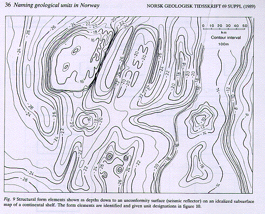
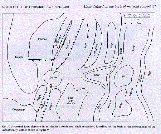
3.7.10.1 A plateau is a positive geomorphological and/or structural form element which consists of an extensive area dominated by a surface of low relief. The levelled surface of the plateau is significantly higher than contemporaneous surrounding areas. A plateau can be formed by tectonic or volcanic processes and/or by erosion (Figs. 9, 10).
3.7.10.2 Every plateau is a high.
3.7.10.3 A plateau has a regional extent.
3.7.10.4 The structure is mappable with the help of geomorphological, geological and/or geophysical methods.
3.7.10.5 A plateau may include several geomorphological and/or structural elements, such as upstanding highs, deep ravines and fault-bounded structural elements. These features are subordinate in area to the even surface of the plateau.
3.7.10.6 A plateau can be given a formal or an informal name in accordance with the "general rules for naming and defining geological units" (Chap. 2) and the rules for naming geological form units (Section 3.7.1). A proper name (Section 2.2.2) is placed between the words "the ... Plateau (formal) in the compound name.
3.7.10.7 If the plateau surface is below sea level the term submarine plateau (undersjøisk platå) is used. Table mountain (bordfjell), mesa and guyot are highs with plateau summits (Bates & Jackson 1980).
3.7.10.8 Examples: The Vøring plateau was originally defined by Nansen (1904). Based on the Tertiary palaeorelief, the Vøring plateau is bounded to the southwest by the continental slope, to the northwest by the Lofoten Basin and to the east by the Vøring Basin. On the basis of the present topography of the sea floor, the Vøring plateau is part of a platform. The "Kroksskogen plateau" and the "Hardangervidda plateau" are terms that are correctly used for plateau-shaped highs.
3.7.10.9 Key reference: Bates & Jackson (1980).