3.7 Geological form units
3.7.1 General properties and rules
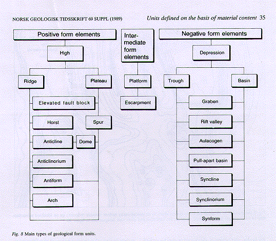
3.7.1.1 Definitions -- In studies of both Quaternary and older deposits it is necessary to define and name geological form units. These are geomorphological elements and form elements related to structural geology (Fig. 8).
Geomorphological elements are present-day and ancient, buried landforms that can be distinguished on the basis of distinctive physical characteristics. Geomorphological units may be (a) depositional forms, such as a moraine ridge, a delta or a beach ridge; (b) erosional forms, such as a canyon or a marginal meltwater channel; (c) forms produced by both deposition and erosion, such as a beach terrace or a kame terrace; and (d) structural landforms produced by tectonic movements, such as a horst or a graben.
Form elements related to structural geology comprise present-day and former structural landforms (group d, above) and structural form elements that have not been reflected at the surface as landforms, or about which nothing is known concerning whether they have at any time found expression in the surface topography. Such structural elements may be an anticline, syncline, dome, diapir, horst or graben.
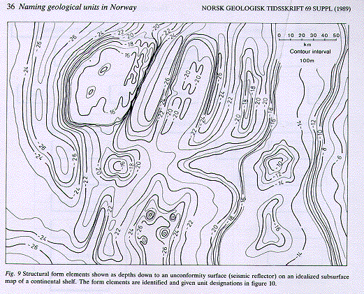
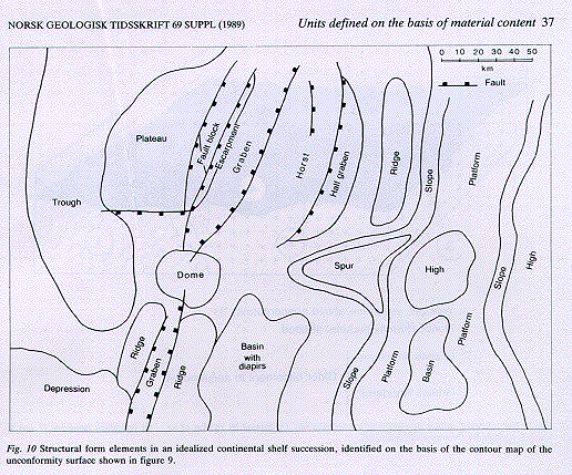
Geological form units can be classified as positive (upstanding) or negative (depressed) (Fig. 8). Geomorphological form elements are directly visible on the surface, while structural form elements in ancient stratal sequences are seen in vertical section. Unconformities may define positive or negative forms, but are in themselves neither positive nor negative (Figs. 9, 10).
3.7.1.2 Identification and mapping -- Geological form elements are identified and mapped in several ways: (a) surface mapping of geomorphological form elements; (b) using geological and geophysical methods to record structural form elements in stratal sequences exposed on land; and (c) using geophysical methods to record subsurface geological form elements on land and on the continental shelf (Figs. 9, 10).
When exploring for economically exploitable subsurface ore and mineral deposits, not least petroleum on the continental shelf, the identification and regional tracing of structural form elements is particularly important. These will be revealed as geophysical anomalies (e.g. magnetic or gravimetric) or be identified in relation to a specific geological or seismic surface by, for example, reflection seismic mapping.
There may also be a need to define and name geological form elements that no longer exist, either at or beneath the surface. These may be former sedimentary basins or ocean basins that are indirectly reflected in a sequence. A distinction is made here between "rooted" and "rootless palaeobasins". Rooted palaeobasins with their infilled sequences are located in the same areas as they were when they formed active sedimentary basins. Rootless palaeobasins are expressed by sequences in the nappes of a mountain chain. Such basins are no longer directly connected to the area in which they existed as active basins.
3.7.1.3 Nomenclature -- The most general terms in the following non-hierarchical system for naming geomorphological and structural form elements are non-genetical (Fig. 8). For example, a "high" is the fundamental designation for a positive geomorphological or structural form element of non-specified origin and shape. An elongate high of undetermined origin can be termed a "ridge". If a ridge is laterally delimited by faults, the origin is clear and it can be called a "horst" (Figs. 9, 10). An "ice-marginal ridge" is another example of a genetical ridge term.
When choosing nomenclature, care should be taken to use the term which gives most geological information. If, for example, it has been shown that a certain structural feature has been formed as a horst, the term "horst" and not "high" should be used. Structural form elements can therefore be redefined during ongoing investigations (Section 2.5.1) as new knowledge about the structure is forthcoming (see also Section 2.4).
Naming takes place according to the "general rules for naming and defining geological units" (Chap. 2). It should be emphasized that the principle that more than one geological unit should not have the same proper name (Section 2.2.2) also applies to this category, except for escarpments (Section 3.7.12) and rootless palaeobasins (Section 3.7.14). An escarpment can be given a proper name after the named structure which it delimits or follows. In the case of rootless palaeobasins, the proper name of the lithostratigraphical unit defining the palaeobasin is also to be used as the proper name for the rootless basin. The proper name of a geomorphological unit which forms an integral part of a morphostratigraphical classification system can also be used for the derived morphostratigraphical unit (Section 3.20).
Geological form units are given formal status with protected proper names when they are defined according to the rules for formal units in Section 2.4.
3.7.1.4 Units -- This category comprises the following geological units: unconformity, high, ridge, spur, fault block, horst, dome, anticline, plateau, platform, escarpment, depression, basin, trough, graben and syncline.