3.10.2 Morphodeme (Morfodem)
3.10.2.1 The morphodeme is a landform produced by deposition and/or erosion, and forms an integral part of a lateral assemblage of corresponding units which together demonstrate a geological process.
3.10.2.2 Morphodeme is the fundamental unit for morphostratigraphical classification and nomenclature.
3.10.2.3 There are no limitations on the dimensions of a morphodeme.
3.10.2.4 A morphodeme should be mappable on the surface using geomorphological methods.
3.10.2.5 A morphodeme is a landform which is identified exclusively on the basis of its distinctive shape. A morphodeme can be formed during a simple geological event, or during an event consisting of several separate episodes. The period of time represented by a morphodeme therefore often varies in length along the extent of the morphodeme (see Sections 3.10.2.7 and 4.7.3-4.7.5).
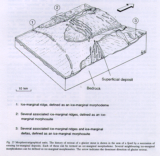
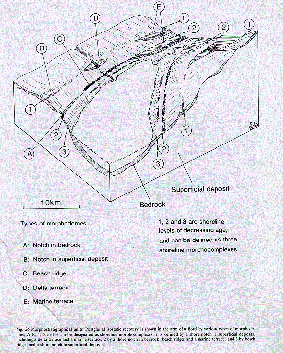
A morphodeme may be an ice-marginal deposit that can be traced laterally as a morphostratigraphical unit (Fig. 25). Such an ice-marginal unit may consist of segments having different modes of formation, composition and age. A morphodeme may also be a marine terrace, kame terrace, beach ridge or some other landform that can be traced laterally as a morphostratigraphical unit (Fig. 26).
3.10.2.6 A morphodeme can be given a formal or an informal name in accordance with the "general rules for naming and defining geological units" (Chap. 2) and according to the provisions in Section 3.10.1.3. The proper name (Section 2.2.2) is placed between the words "the ... Morphodeme" in formal names, perhaps with a descriptive term such as "ice-marginal", "terrace", "beach ridge", in front of "morphodeme". If misunderstanding about the meaning cannot arise, the unit term "morphodeme" can be omitted from the name once the unit has been formally defined (see Section 3.10.2.8).
3.10.2.7 A morphodeme may consist of one or more formally or informally defined geomorphological elements (Section 3.7). The total time interval of the morphodeme may be a phase, span or cline (see Sections 4.7.3-4.7.5).
3.10.2.8 Examples: Long-established examples of morphological units in Norway are Pleistocene--Holocene ice-marginal deposits and beach terraces. Morphostratigraphical ice-marginal deposits have been called "linjer" ("lines") or "trinn" ("stages") (e.g. "Ra-trinnet", "Ski-trinnet", "Aker-trinnet" (Holtedahl 1953). The term "trinn" was used by Kjerulf (1879) as a term for marine terrace surfaces. Holtedahl (1924, p. 11) also originally used "trinn" in a purely morphological sense about ice-marginal deposits. By degrees, the word "trinn", used for ice-marginal deposits, obtained a time connotation (Norsk Riksmålsordbok, p. 2946) and was translated into English as "stage" or "substage" (Holtedahl 1960). In line with this meaning of "trinn", the word "stadium" (plural "stadier") became used as a kind of morphostratigraphical term (Anundsen & Simonsen 1967). Mangerud (1973) proposed that "trinn" should be used as a morphological term, and this has been largely practised since that time. In this Code, "trinn" is defined as a diachronous unit (Section 4.7.4), and it is proposed that the word "span" should be used as the equivalent English term. The English terms "stage" and "substage" (along with the associated Norwegian word "stadium") denote, and should only be used for, chronostratigraphical units (Section 4.2.6).
The prominent ice-marginal ridge called the Ra ("Raet") in ¥stfold and Vestfold, in South Norway, is an important morphostratigraphical unit (Andersen 1960). It should have the rank of a morphodeme, the Ra Morphodeme ("Ramorfodemen") or "the Ra Ice-Marginal Ridge" or simply "the Ra Ridge". (Portions of the Ra may have been given geomorphological proper names. The term "ra" has traditionally been used as a common name for several major and minor ice-marginal ridges elsewhere in the Oslofjord region.)
3.10.2.9 Key reference: this Code.