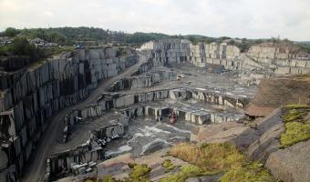
The superficial deposits within the map sheets are discribed and classified according to their genesis. Within map sheet Brattvåg both land and sea areas are mapped. The dominant deposits...
The map-sheet Båtsfjord covers an area belonging geologically to the Barents Sea Region. Two major lithostratigraphic units occur within the confines of the map-sheet: the Lokvikfjellet a...
The different rock-types within the map-area are discribed. Four tectonostratigraphical elements are recognized: 1. Precambrian crystalline basement; 2. The autochthonous Kinnfokfjellet F...
The superficial deposits occuring within the map-area are described and classified according to their genesis. In the mountains a discontinuous or thin cover of till dominates with peat i...
Petrographic and structural descriptions are presented of the different rock-types occurring within the area of map-sheet Arstaddal. The area investigated is situated in the Breiarn Nappe...
The superficial Quaternary deposits occuring within the map-sheet area have been classified and mapped according to their genesis. Fine-grained marine deposits dominates in the main valle...
The superficial deposits within the map-sheet are described and genetically classified. Tills are the dominating sediments, but considerable amounts of glaciofluvial and fluvial deposits ...
The map gives a total evaluation of the water yield capacity from the best aguifers, either bedrock or superficial deposits, marked by colours from yellow to bluish green. The map also de...
Investigations of sand and gravel aquifer below the marine limit in Solør, southeastern Norway have shown the following realtionships between the sedimentological and the hydraulic prober...
The superficial deposits occuring within the map-area are described and classified according to their genesis. In the mountains a discontinuous or thin cover of till dominates with peat i...
The superficial deposits occuring within the mapped area are classified according to their genesis. Finegrained marine sediments are the dominating deposits. The map covers one of the b...
The superficial deposits within the map-sheets are classified genetically and described. The icemarginal line "Bremsnestrinnet" is reconstructed from the positions of terminal m...
The superficial deposits occurring within the map-area are described and classified according to their genesis. In the mountains till and organic deposits dominate. In the lowland areas g...
The superficial deposits and their morphological features within the area of map-sheet Nordfjordeid, western Norway, are classified and described. Ice movements and the course of the deg...
The superficial deposits occurring within the area covered by the map-sheets are classified genetically and described. Most of the deposits are tills covering wide areas in the southeast,...
The superficial deposits within the map-sheet Kilebygd, southeastern Norway, are classified and described. Most of the area is dominated by exposed bedrock or a thin and discontinuous cov...
The volume takes the form of a monograph over all minerals recorded on the mainland of Norway up to 1980. Some mineral data which have come to light in more recent years, published or unp...
The superficial deposits within the map-sheet are classified genetically and described. The ice-marginal line "Tingvolltrinnet" is reconstructed from the positions of terminal m...
The superficial deposits ocurring within the map-sheet area are classified according to their genesis and described. Till is the dominationg sediment, but considerable glacifluvial deposi...
The superficial deposits occurring within the map-area are described and classified according to their genesis. In the mountains, till and organic deposits dominate. In the lowland area...
The superficial deposits within the area of map-sheet Reisadalen, 1734 III, in nothern Troms, North Norway, are classified according to their genesis and described. Ice movements and the ...
The superficial deposits occurring within the area of this map-sheet are classified according to their genesis and described. Based on glacial striae and till stratigraphy 3-4 regional an...
The superficial deposits within the area of the map-sheet Askvoll, in western Norway are classified and described. Ice movements and the course of deglaciation are reconstructed. The thin...
Three principal geological and tectonostratographic divisions of the bedrock can be recognised within the are of map-sheet Nordkapp: 1) the Kalak Nappe Complex, 2) the Magerøy Nappe, and ...
The superficial deposits occurring within the map-sheet are described and classified according to their genesis. Short accounts are also given on sand and gravel resources and groundwater...
The superficial deposits occurring within the map-sheet are classified and described according to their genesis. The ice-marginal lines - Repparfjord- trinnet and the younger Hovedtrinnet...
The map-sheets Lønsdal and Graddis, 2128 III and 2128 II, cover parts of the area of a Quaternary mapping programme carried out by NGU in the Saltfjellet district of Nordland, north Norwa...
The superficial deposits within the map-sheet Nordatugu, southeastern Norway, are classified and described. Most of the mountainous areas are dominated by exposed bedrock or a thin and di...
The map-sheet Bjøllådal, 2028 II, covers a part of the area of a Quaternary mapping programme carried out by NGU in the Saltfjellet district of Nordland. The superficial deposits are clas...
The main tectonostratigraphic units within the Melvær and Askvoll map-areas are: Precambrian basement rocks, allochthonous Precambrian charnokitic- mangeretic rocks of the Dalsfjord Nappe...
The superficial deposits within the map-sheet Hølonda were formed during the Late Weichselian and Holocene. At the time of deglaciation the sea-level was situated ca. 175 m above the pres...
The superficial deposits within the map-sheet are classified according to their genesis and described. Glacial striae indicate a southerly directed ice movement through most of Weichselia...
The superficial quaternary deposits occurring within the map-sheet area have been classified and mapped according to their genesis. Till dominates in the lower part of the area. Considera...
Following a short historical review of uranium prospecting in Norway, most of which has been done by the Geological Survey of Norway, a simplified description is given of radioactivity, r...
The superficial deposits within the map-sheet are classified genetically and described. Moraines dominate the superficial deposits. These, together with glaciofluvial deposits, are descri...
The superficial deposits within the map-sheet are described and classified according to their genesis. Glacial striae indicate a southward ice movement through most of the Weichselian. Th...
Områder under marin grense kan være utsatt for kvikkleireskred. Dagens aktsomhetskart for disse områdene hos NVE er basert på NGUs løsmassekart og marin grense-datasettet. I
områder med ...
Områder under marin grense kan være utsatt for kvikkleireskred. Dagens aktsomhetskart for
disse områdene hos NVE er basert på NGUs løsmassekart og marin grense-datasettet. I
områder med...