Velkommen til
LITO-prosjektets hjemmeside / Welcome to the LITO project's homepage
 Bakgrunn og status / Background and status
Per i dag
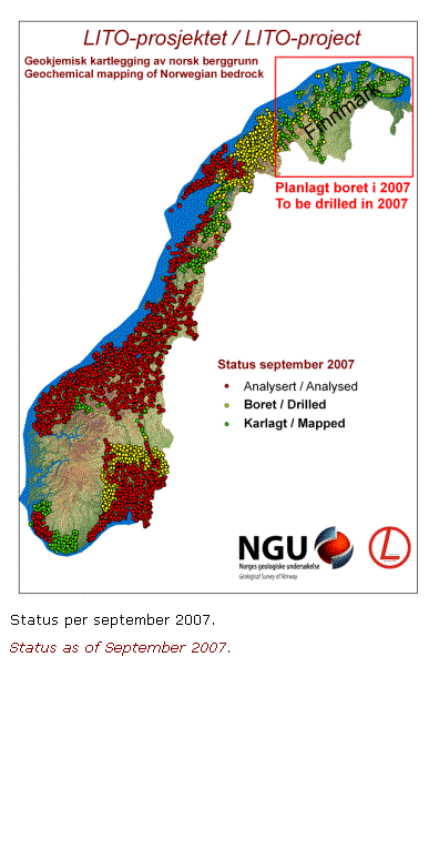
er 2200 av i alt ca. 3800 lokaliteter prøvetatt (kart til høyre). Av disse er 1616 prøver ferdig analysert (i
rød farge på kartet).
To this day, 2200 of c. 3800 planned locations have been sampled (map
at right). Of these, 1616 samples
have been analysed (in red on the map).
Hvordan
påvirkes kvaliteten på grunnvannet av bergartenes sammensetning? Hvor mye varme produserer egentlig
berggrunnen i Oslo-området? Hva er den
naturlige variasjonen av arsen og kadmium, og hvor mye skyldes våre egne
utslipp av disse miljøgiftene? Disse,
og andre spørsmål, kan NGUs LITO-prosjekt gi svar på.
How does bedrock composition
affect the quality of groundwater? How
much heat do the rocks in the Oslo-area generate? What's the natural variation
in arsenic and cadmium concentrations, and how much does human emissions of
these environmental poisons contribute?
NGU's LITO-project can provide answers to these and other questions.
I 1999,
etter 33 års arbeid, sluttførte NGU produksjonen av geologiske
kart over Norge i målestokk 1:250,000.
De til sammen 43 kartene gir opplysninger om bergartstyper, utbredelse
og innbyrdes forhold, og er et viktig bidrag til kunnskap om landets
geologi—både som grunnlag for forskning og forvaltning.
In 1999, after 33 years of
work, NGU completed production of the 1:250,000
scale map series of Norway. The
altogether 43 maps yield information about rock types, their distribution and
relationships, and provide important knowledge about the country's geology—both
as a means for research and area planning.
Kartene
sier derimot lite eller ingenting om bergartenes sammensetning. selv om slik
informasjon er viktig innen geologisk grunnforskning, i miljøspørsmål, for
utnyttelse av naturressurser som grunnvann og grunnvarme, og forvaltning og
identifikasjon av mineralressurser. Med
dette som utgangspunkt startet NGU i 1999 et landsomfattende prosjekt,
LITO-prosjektet (lito=stein), hvis formål er å bestemme de geokjemiske og
petrofysiske egenskapene til Norges berggrunn med basis i 1:250.000 kartserien.
The maps do, however, provide
little information about the rocks' composition, despite the significance of
such knowledge in basic research, in environmental issues, exploitation of
natural resources like groundwater and geothermal energy and area
planning. In 1999, with these issues in
mind, NGU initiated a nation-wide project, the LITO-project (lito=rock), with
the purpose of determining the geochemical and petrophysical properties of
Norwegian bedrock based on the 1:250,000-scale map series.
Minst
3800 prøver vil bli samlet inn fra alle deler av landet. Alle data vil bli gjort tilgjenglig og
tilrettelagt for allmennheten.
At least
3800 samples will be collected from all over the country. All data will be made available to the
public.
Tilbake til hovedsiden / Return to main page.
Last updated 08.09.2007 Trond.Slagstad@ngu.no http://www.ngu.no/slagstad